
Being locked up in hotel quarantine for two weeks gave me a decent amount of time to re-familiarise myself with the local Australian bush using maps. I dug up my old Google Earth files and loaded them up. All the names I saw looked familiar but to took me a while to start linking all the places back together in my head. Whilst the satellite imagery is nice to use, having a topographic basemap is also indispensable. The ‘network links’ to the SIX Maps servers I had made were still working but these had always been unreliable and cantankerous.
Online you can view the NSW topo maps via different interfaces. The normal maps.six.nsw.gov.au site works great. There you can configure one of the base maps to be the current topo maps, as well as overlay important information such as ‘lot boundaries’ which can be useful when exploring areas near private property. You can also view the first edition maps, and ozultimate has created a nice interface allowing you to fade between the two. In fact maps.ozultimate.com looks great and appears to have improved on the topo.notto.be site allowing you to upload kml, gpx or json (the advantage of topo.notto.be seems to be that you can send a link with points included in the URL. EDIT: actually they both do this). This NSW Bushwalking Maps page offers some more information and options: maps.ozultimate.com/wiki/resources

Enabling the Topo Maps layer on SIX Maps 
Enabling the Property Boundaries layer on SIX Maps


Whilst all these resources are great, having more layers and overlaying my own data is important to me. GIS programs like ArcGIS and QGIS always seemed a little clunky, running slowly and having loads more features than I ever seemed to need. I continued to return to Google Earth.
In Google Earth, one alternative to overlaying topo maps using SIX Maps ‘Network Links’ was to use the NSW Topo ruby script to export a kmz. This works great but isn’t that user friendly.
Browsing the internet I also found that the SIX Maps server now allows the public to download GeoPDFs for free. If you visit maps.six.nsw.gov.au/etopo.html you can see the state overlayed with small green and red rectangles. Green just means that the printed map is available for sale.

It is a simple process to click on the map you want. Select the “PDF” radio button and then the “Download PDF” button. This PDF might be all you might want. You can now print out the topo map, or just the section you want for your trip. You could also load the map into certain applications for navigation (like Avenza though I’ve never used it).
I couldn’t get Google Earth to open GeoPDFs but using QGIS you can convert it for free into a GeoTiff. This can take a little while and uses quite a bit of your CPU. (Another way would be to use GDAL).
If you want to do this, first you need to install QGIS. Grab it from HERE (or this direct standalone link for Windows). Once it is installed drag your GeoPDF into the “Layers” pane (or use the Layer -> Add Layer -> Add Raster Layer…).


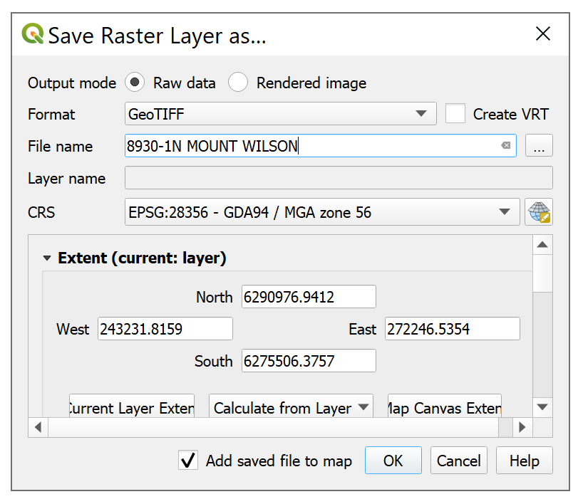
You can then right click the layer (the PDF you imported), and choose Export -> Save As…
You can then select GeoTiff from the dropdown menu and enter the name you want to use for the resulting file. I think using the same name as the PDF is a good idea.

Now you can drop that GeoTiff into Google Earth (or use Add -> Image Overlay).
You might get a message that your computer hardware won’t support an image so large. Don’t worry! You can create a Super Overlay which basically chops the map up into small parts so that your computer only has to draw a small part at a time (I found that the “Scale” option provides a poor resolution in most cases).
When you create the Super Overlay, be sure to create a new folder to store all the resulting files as there’ll be lots!

That’s it! You should now be able to peruse the map from within Google Earth, overlaying your own points and tracks. Measuring distances, fade in between the topo map and the satellite imagery (Use the “Adjust Opacity” slider at the bottom of the “Places” pane).
You can also overlay information like the recent fire damage (GEEBAM dataset here). See the image below.
I hope this helps someone and feel free to comment if you have any suggestions or a better way to do things. Cheers.


