
Over summer, whenever there has been rain or the forecast for the weekend ahead looks ominous there is an inevitable stream of people asking whether the particular canyon they plan to visit will be safe, or if the risk of high water or potential flash floods make it too dangerous.
The answer, as with most risk factors, is almost always the same: it depends.
The official position, as outlined in the Canyoning Code of Ethics, is to “avoid canyoning if rain is forecast or if the weather looks changeable.” Experienced canyoners will generally advise that — unless you are familiar with a particular canyon and know how it responds to wet conditions — you should not go canyoning the day after heavy rain, particularly if more rain is forecast.
But no two canyons are exactly the same, meaning no two canyons will respond in an identical way to a particular set of circumstances. Likewise, a storm cell can be so localised that one canyon will flash flood, while the neighbouring catchment remains bone dry.
Some people also make the mistake of basing their decision on reports of canyoning tragedies overseas — such as the flash flood in recent years that killed an entire group of seven in Utah — but fail to understand the fundamental differences between the conditions in Australian canyons and those in the United States, Europe, New Zealand, and elsewhere.
The following article is written specifically in the context of canyons in the greater Blue Mountains area, with their unique geology and ecology. It provides a summary of the key factors to consider when planning a trip after rain, or when rain is forecast. It outlines the elements that can make particular canyons more dangerous than others, as well as suggesting ways you can mitigate this risk. It also provides a series of links to online tools that will provide you with the information you need to make an informed decision.
Flash flooding and extreme weather events are just some of the many risk factors when venturing into the bush. Canyoners also face the danger of falling rocks, landslides, bushfires, snakes, slippery surfaces, falling trees, and countless other things (not to mention the drive to the start of the canyon, which is statistically the part of a trip that is most likely to kill you).
Don’t let fear of thunderstorms and flash floods prevent you from canyoning. Instead, make intelligent, informed, deliberate choices to reduce that risk as much as possible, then get out into nature and enjoy yourself.
DISCLAIMER: This is general advice only. Each situation is different and everyone has to make their own assessments of the particular risks they face. The following is not intended as a step-by-step guide, rather it provides information and advice that may assist with improving your own approach to mitigating particular dangers while canyoning in the Blue Mountains. Any activity in the bush carries some risks. We take no responsibility for any incidents or accidents caused by people uncritically following the points below.
Are flash floods a risk in Blue Mountains canyons?
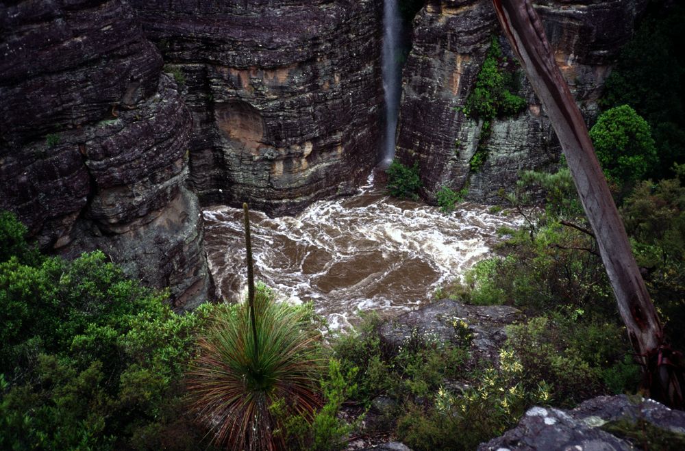
Flash flooding is a genuine risk to be aware of when canyoning in the Blue Mountains. Over the past few decades there have been a number of incidents where fast-rising water has claimed lives. In the most tragic example, a group of three people — including two experienced canyoners — died in Claustral. More recently, the usually benign and very much beginner-friendly Empress Canyon claimed a life. When you speak to experienced canyoners, most have first-hand stories of near-misses due to extreme weather or high water levels. Or simply look up at the logs jammed high between the canyon walls on your next trip and consider the scale of the flash floods required to position them there.
While flash floods do occur, the risk of one taking place on any particular trip is generally extremely low. In part this is because of the unique features of Blue Mountains canyons that make them much lower risk than many others around the world. These factors include: extensive vegetation and swamps that absorb and slow runoff; less sustained constrictions making escape or finding a safe refuge easier; fewer long swims, warmer water and a generally drier nature; and a lack of keeper potholes and other obstacles that slow progress. Many of our popular canyons also have quite small catchments.
It is highly unlikely you will ever experience a Hollywood-style ‘wall of water’ surging through the canyon, but intense rainfall from thunderstorms and other extreme weather events can cause water levels to rapidly rise, with normally-easy obstacles becoming extremely dangerous. If you do become trapped in a narrow, high-walled constriction, you may not have any options available to scramble to safety.
Looking at the numbers, the situation is quite sobering. One millimetre of rain falling across one square metre of ground provides one litre of water. Multiply that across a square kilometre and you suddenly have a million litres. Now consider that an intense storm cell can dump tens of millimetres of rain in a matter of minutes and you can see how flash floods occur. To provide a tangible example, Claustral Canyon has a catchment of about 2.6km² just above the Black Hole. This doubles to 5.3km² at the junction with Ranon Canyon (it was below this junction that Australia’s worst canyoning tragedy occurred). If an intense storm cell dumps 50mm of rain over that entire catchment — which is by no means an extreme example — 260 million litres of water will suddenly have been deposited. Put another way, that amount of water is enough to fill more than 100 olympic-sized swimming pools. Any water that can’t be held back or absorbed by the vegetation and soil will flow down into the narrow canyon constriction.

What are the factors that increase flash flood risks?
While it’s impossible for canyoners to control whether an intense burst of rain will fall over a particular canyon, there are a huge range of factors at our disposal that assist with making informed safety decisions.
1) The physical characteristics of the canyon:
The size of a canyon catchment will determine how much water can land upstream and potentially flow through the constriction. The bigger the catchment, the more water that will arrive from a single rainfall event, the larger the amount of runoff that will potentially reach you.
The next factor is how absorbent the catchment is. For instance, canyons with large amounts of rock or bare earth will have more water run off, while vegetation, soil, and leaf litter will all hold onto water. The leaves on trees hold onto a huge amount of water when it rains, while sandy soil is capable of quickly draining water from the surface. Many Blue Mountains canyons also contained swamps, which act like sponges and can hold many times their dry weight in water. Be aware that valley swamps, such as those above Fortress Canyon, are capable of slowing down a greater quantity of water than hanging swamps because of the flatter topography. All swamps have a maximum water-holding capacity, so you also need to consider that once they are fully saturated they then allow all further rainfall to flow through to the canyon.
Factors like bushfires or severe droughts can also change the ability of a catchment to hold back water, as the existence of less organic material reduces how much rain is absorbed before running off. The existence of recently burnt areas, particularly burnt swamps, will substantially increase the flash flooding risk in a particular canyon.
The shape of the land can also slow a flash flood, with less steep hillsides able to hold more water before it flows off, while steep slopes have the opposite impact.
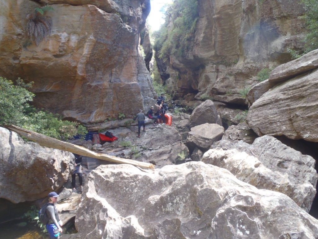
The canyon itself is also a significant factor. A narrow constriction requires much less water to fill up. For canyoners, a long, deep section of canyon also makes it harder to find exit points or refuges in the event of rising water.
Human impacts above the canyon also influence the likelihood of a flash flood. Urban or even agricultural areas in the catchment, which include hard surfaces, bare soil, and less biomass, will result in runoff occurring more quickly and a flash flood being caused by less rainfall. Empress Canyon is the best example of this, as urban areas make up more than a third of the catchment. When it rains water rushes off roads, roofs, and other hard surfaces and into the creek system. Human influences can also lower the risk, such as dams and other structures that hold back runoff. Grand Canyon is the prime example of this, with a large part of the catchment flowing into two water supply dams.
Also worth considering is that many canyons with relatively small catchments flow into much larger creeks. While the conditions might be safe enough within the confines of a canyon like Whungee Wheengee or Hole In The Wall, both have exits that require moving through major watercourses with huge catchments.
2) Recent and forecast weather conditions:
Blue Mountains canyons have the ability to drain quite quickly after rain, often returning to normal water levels within hours. But while the flow in the creek may not appear dangerous, if the soil, plants and organic matter in the catchment are already saturated, and further rainfall that lands in a catchment will run off the surface and into the watercourse. Heavy rain — in particular during the 48 hours before your trip — can have a very significant impact on the flash flooding risk. Put simply, once the catchment is saturated, even a relatively small amount of rain can cause water levels to rise.
Be aware that catchments can often be saturated by local weather incidents. Just because it has been fine in Sydney doesn’t mean your chosen canyon hasn’t just received a soaking.
The forecast weather for the day of your trip are also important. While light showers will generally pose no risk, the forecast of heavy rain — particularly from thunderstorms — means the chance of flash flooding will be higher. Other weather systems, such as an East Coast Low, can dump huge amounts of rainfall, but generally come with more advanced warning. Weather forecasts can change quite drastically over time, so make sure you monitor the situation right up until the morning of the trip.
Large-scale climatic systems should also be considered. The East Coast of Australia is extremely susceptible to the impacts of El Niño and La Niña weather patterns. While the first — which often accompanies drought years — will reduce the risk, the second generally means above average rainfall should be expected.


How do I decide if a canyon is at high-risk of flash flooding?
1) Check how much rain has fallen in recently:
As well as examining the recent rainfall observations at nearby weather stations (Mt Boyce is generally the most useful), the Bureau of Meteorology has a handy tool that lets you see how much rain has fallen across the entire Blue Mountains during the past week. Using the 128km Sydney rain radar, click on the “24 hour” option. This shows the total rainfall recorded during the proceeding 24 hours. Better yet, under the “Radar controls” heading there are arrows that allow you to click back and see the total rain recorded each day during the preceding week. You will quickly notice that the rainfall across the mountains is rarely even, and while some canyoning areas may have received a lot of rain, others may not have.

2) Check the weather forecast:
Weather forecasts are produced using complex weather modelling algorithms. Most are actually an averaging of multiple sets of predictions. Differing assumptions and inputs change the results. They also become more accurate the closer you get to the day of your trip. I recommend watching them closely right up until the day of the trip.
As well as the general forecasts provided by the BOM, the MetEye system provides incredibly detailed forecasting. You can zoom in on the map or search for a specific locality. It can be used to the amount of rain predicted to fall in a particular area, with the information broken down into three hour time periods.
Many bushwalkers and canyoners also use the Norwegian weather service Yr.no. Not only does it provide similar, three-hourly weather breakdowns for specific areas, but the weather modelling is generally quite reliable.
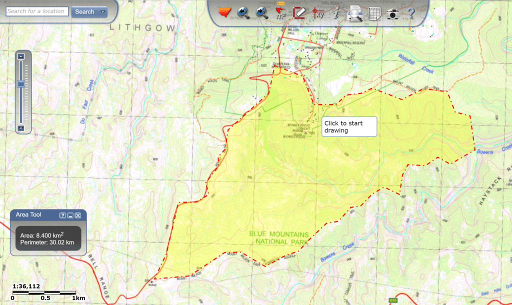
3) Check the size of the catchment of your chosen canyon:
Better than just having a general look at a topographic map, there are online resources that can help provide accurate calculations of the size of your chosen canyon’s catchment.
The sizes of many popular Blue Mountains canyon catchments have been helpfully calculated by Tom Brennan.
If your canyon isn’t on that list, the easiest way to work it out yourself is with the SIX Maps website. Set the basemap to topographic, then click on the “area tool”. Use it to trace around the outside of the canyon catchment. Once finished it provides a precise figure of the catchment size.
If you are planning on visiting Grand Canyon you can also check the current water levels in the upstream dams. Water NSW combines the storage levels of both dams for some reason, but the BOM helpfully provides a breakdown for just the lower, Greaves Creek Dam (which is the most significant one).
4) Build up your understanding of how the bush responds to rain:
Next time you are caught by rain in the bush, use the opportunity to watch how the environment responds. Compare the runoff from rocky, cleared, vegetated, and heavily treed areas. Once home, examine how much rain fell. All of these experience will help you determine what a safe amount of rain is in various landscapes. Personal experience is a vital component of making good assessments of risk in the bush.
What should you do on a canyoning trip to reduce the risk?
If you’ve decided to press ahead with your trip, after assessing the risk, there are a number of steps that should still be taken to ensure you stay safe.
1) Make an early start:
Intense thunderstorms are the most likely causes of flash floods. Storms are very unlikely in the morning. Thunderstorms are more likely to occur from the early afternoon. Setting off early enough so that you are through the canyon constriction by lunchtime will substantially reduce the risk of being caught in a flash flood.
2) Be willing to turn back:
Make sure you know the final decision point for a canyon from where it is still possible to exit. By the time you are at this point you will have had the opportunity to observe the landscape and see whether it is saturated or there are other factors that will increase runoff. You will also have had a chance to monitor what the weather is doing, particularly if there are storm clouds looming. Finally, you’ll be able to see the water flow going into the canyon. It is advisable to have at least one person in your group who is familiar with the canyon so they can compare the situation to normal conditions.
Don’t be afraid to to make the decision to turn back. If you determine that these risk factors are elevated, you should avoid the canyon. It will still be there for future trips.
3) Move efficiently:
Keeping your group small and moving efficiently are always good advice. It keeps you safe by stopping people from getting cold, tired, or benighted. It is particularly important however if there is the risk of flash flooding. Being able to move quickly and safely through a constriction means less chance of getting caught.
For a canyon like Claustral, consider taking three ropes, set for the length of each abseil in the Black Hole. For canyons that have more spread out abseils, make sure the first person down each drop has a rope so they can set the next abseil by the time the group arrives.
4) Keep an eye out for possible refuges:
As you move through the canyon, keep your eyes out for possible exits, or refuges that would keep you out of harm’s way. Water levels can drop almost as quickly as they rise, so sheltering for a couple hours under an overhang or in an area between constrictions is generally a better option that trying to race through the canyon once heavy rain is falling. The best advice if serious rainfall is imminent or you notice a sudden rise in water flow is to get to high ground as quickly as possible.
5) Remember the other risks associated with rain:
Flash flooding isn’t the only risk factor that comes with wet weather. Wet weather often means colder conditions, adding to the risk of hypothermia. It can also make rock more slippery, particularly in areas like Kanangra. Recent rain also increases the risk of landslides and loose rocks. Also worth noting is that sandstone loses a lot of strength when wet. Particularly on canyons where there is rock scrambling involved on the entrance and exit, recent rain can increase the chances of holds breaking.
* * * * *
Have I missed anything? Do you have any other good tips to help manage the risks pose to canyoners by flash floods and extreme weather? If so, leave us a comment and we’ll incorporate it into the article.
Hi Tim,
Awesome article. However, I will argue a little, that 50mm per hour of precipitation actually is pretty extreme! I don’t think I’ve seen weather station records in the Sydney region with rain that heavy for a while, if ever…happy for someone to dig through the BOM archives and find some!
Most weather resources would say rainfall of above 10mm or 20mm per hour is considered very heavy. For example, the storms on Tuesday night dropped 15mm at Mt Boyce ( http://www.bom.gov.au/products/IDN60901/IDN60901.94743.shtml ) in the half hour before 7pm, about 5mm fell. So that was a maximum rate of about 10mm an hour.
I don’t have any data handy, but I know when I’ve looked around previously I have read reports of massive slow-moving supercell storms that have struck parts of NSW over the decades (I remember a huge one near Wollongong that delivered more than 700mm of rain over the course of several hours).
I think that in a canyoning situation people are more likely to get caught out by a localised supercell storm. They often take less than an hour from forming to dumping their rain, making them more likely to catch people by surprise. The localised nature also means they are dropping all that rain over a small area, so they’re unlikely to get picked up by a weather station — there’s only one in the Blue Mountains that provides hourly data. If you look at what is recorded on the radar over a period of a few hours the amount of rainfall can be extremely intense.
I was in the army in 1987 at Holsworthy range when the rain gauge at the military airstrip south of the range received 253mm between 9am & 3pm (40mm+ an hour), whilst nearby Appin received 71mm & Liverpool 47mm. Such extreme events can be severely localised and I would say nearly all of that occurred within a one-hour period. I know we were dug in to stage-3 (five feet) with overhead protection, yet every pit in the platoon was filled within about four minutes such was its ferocity. At its peak (possibly only 20 minutes) it was physically painful to endure. Simply precipitation but huge drops & so dense that the heads of those in the rifle pits each side of me (less than 10m away) where impossible to distinguish for most of that time. I’ve seen & experienced other intense downpours in the tropics and northern Australia in the wet. but that still remains the most intense pure rainfall event I’ve ever seen and it occurred within the Sydney basin.
Jamie, thanks for sharing that amazing experience. I don’t think it’s possible to fully comprehend the power of nature until you get stuck smack-bang in the middle of a freak weather event like that.
Storm cells dumping >50mm / h in localised areas are not uncommon. We were almost caught by a very localised storm cell over the Hole in the Wall catchment last year – looking at the radar later there was about 50mm in the less than 1hr storm. Tim, in relation to the “wall of water” scenario – we’d rushed through the end of the canyon once the heavy rain started and the water was rising – once we were on the ledge opposite the end in the Bungleboori – we heard what sounded like a plane, then all of a sudden this jet of water started shooting out of the end of the canyon. I would not have wanted to be in the canyon when that happened!
In other words, while not so common – it can happen that way here.
On that trip we went quickly downstream another few hundred metres to find a higher ledge to wait it out, during which time the water rose another couple of feet.
Wow, what a close call. You didn’t manage to get any photos or video of the jet of water did you?
Also worth noting that Hole in the Wall has quite a small catchment — just over two square kilometres — so the same rainfall event hitting many other canyons could have caused an even more extreme flash flood.
I got flooded out of Hole in the Wall in the early 2000s. Water levels up a bit to high to begin with after a wet week. On the day it was raining hard in Lithgow but clear on the plateau. We got through the top section but the lower section looked a bit dicey and thinking of what the Bungleboori would be like we decided to reverse back up the top section.
As we left the big “lunch cave” between the two section heavy rain struck. By the time we got back to the top section the water coming out of final chute was like the wall of water Mitchell describes and we had to bridge up and over it to access the canyon. Once above that what had been shallow wades were now deep swims. At the time I was in the local swimming club so was a reasonably strong swimmer but the 15m swim against the current in the narrow section was the hardest 10km swim I have ever done and I had to set a rope to drag the others through. By the time we got out the rain had eased but the usually dry entrance track was a still cascade of water feeding the canyon.
Great article.
I’ve been through Wollangambe One 3 times already so have some experience of it, but I’m trying to decide whether or not to postpone a trip scheduled for tomorrow.
A thunderstorm in the area dumped 7mm of rain today, with the possibility of more falling before midnight tonight and there is a thunderstorm forecast for tommorrow afternoon.
I was thinking with a group of 7 (mostly newbies) I could get them through to the exit by midday for lunch.
What do you think?
Stephen, personally, I think you’d be fine tomorrow. The Wollangambe is quite wide (compared to the slot canyons that flow into it) and it requires a lot of rain to impact the flow significantly. It seems that between 25 and 50mm of rain fell across a south to north band from the storm today. By tomorrow, you won’t even notice that in the ‘Gambe. Looking at the MetEYE service that BOM now runs (go to http://www.bom.gov.au/australia/meteye/ and enter Mt Wilson) there appears to be little chance of more than a few millimetres falling tomorrow. This amount of rain is completely safe. I also agree with your approach of starting early and exiting the river by lunch time. Severe thunderstorms are extremely rare before the middle of the day, so you’ll be clear of the river before any downpours occur.