
The proposal to raise Warragamba Dam is like a political zombie — a bad idea that despite being buried almost two decades ago just refuses to die.
And even though it comes with a price tag of at least half a billion dollars, the proposal to extend the existing dam wall upwards by 23 metres has suddenly found some serious backers.
It was resuscitated by Infrastructure NSW late last year, with a recommendation to raise the dam wall included in the 20-year State Infrastructure Strategy.
Since then it has been earmarked by Tony Abbott in his “100 dams” water plan and Julia Gillard has pledged $50 million towards examining the idea. In NSW, the O’Farrell Government is seriously considering the proposal, the Opposition isn’t opposing it, and the insurance industry and land developers are gleefully jumping on the bandwagon.
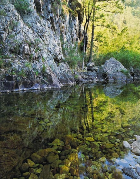
But while the engineers salivate over getting their hands on a massive infrastructure project, no one has discussed the obvious impacts, primarily the inundation of thousands of hectares of World Heritage wilderness in national parks upstream of the dam. Among the worst affected will be spectacular reaches of the Kowmung, Coxs and Nattai Rivers.
The proposal — a case of déjà vu
At the moment no one has produce a detailed, new plan. What they have done is trot out the proposal developed more than 20 years ago. At that time, engineers discovered that the existing dam wall could not cope with a massive flood, and was at risk of collapse. The proposed solution was a massive expansion of the dam wall.
Thankfully, after a three year community campaign, in 1995 the incoming government rejected that proposal. Instead the risk was removed by spending a much more modest $150 million on an auxiliary spillway which ensured the dam would never fail while also maintaining current water levels upstream.
As far as everyone was concerned, that was the end of the matter, until Infrastructure NSW breathed life back into the debate late last year.
Their recommendation to the NSW Government is for a review of all the flood mitigation options available in the Hawkesbury Nepean Valley, “including raising the Warragamba Dam wall”.
The report estimates the cost of the dam proposal to be “at least $0.5 billion” and recommends it be funded not by government, but by “users”. I’m not quite sure who the users of a flood mitigation dam are, but I can only assume that means it will be paid for through a levy on the water rates, council rates or insurance premiums of people living downstream of the dam.
So why is it a bad idea?
Flood waters backing up behind a dam wall are very different to a natural flood. Because the waters are stationary, large amounts of silt and debris are deposited, coating plants and clogging waterways. Natural flooding is also short-lived, but a flood mitigation dam can hold back the waters for weeks or longer if required, drowning river bank vegetation. Once the bank vegetation is killed it will lead to erosion and weed invasion.
Thousands of hectares of internationally recognised wilderness will be damaged.
Up to half the surviving population of the threatened Camden White Gum would go underwater during flood events, threatening the species’ very survival.
Extra soil stripped from the 7,500 hectares of land that would be intermittently flooded will silt up the dam and smother the lower reaches of the pristine wild rivers that flow into the dam. River banks will be eroded, and the slopes will slump.
This damage won’t just occur in remote, unseen places. At full capacity the waters of Lake Burragorang would reach into the Kedumba Valley — past where the Mt Solitary walking track crosses the river — and even be visible from the Three Sisters. Vegetation scarring would be visible from the most popular tourist destination in the Blue Mountains.
At least 300 known Aboriginal sites would suffer damage and accelerated erosion.
Even with all this damage, the dam would only capture half the waters flowing into the catchment area, and extensive damage will still be caused to existing infrastructure in a major flood.
Most worryingly, some of those pushing this proposal see it as an opportunity to open up low lying rural land on the fringe of the north-west growth area for urban development. If the raising of Warragamba Dam lowers the level of the one in 100 year flood level — the level modern housing is not allowed below — huge tracts of land could be developed.
Infrastructure NSW highlights this, saying: “approximately 8,000 residential lots and 60 hectares of commercial and industrial land that have not been developed due to evacuation constraints”.
It continues: “There are a number of other developments currently in the planning phase where it is likely that flooding constraints will be a significant factor… These include more than 8,500 residential lots and over 150 hectares of commercial and industrial land.”
And in the most extreme floods — one-in-500 and higher — the dam will offer no protection. The flooding of Brisbane in 2011 was a one-in-1000 year event.
So essentially, taxpayers are being expected to fork out a massive amount of money to create an environmentally devastating piece of infrastructure so developers can open up valuable tracts of land, and in the worst floods it won’t provide any benefit.
What are the alternatives?
Even Infrastructure NSW accepts that there are alternatives. In their report, they say that if the dam is not raised, “roads in the Hawkesbury Nepean Valley should be upgraded to ensure people can evacuate.”
Shockingly, years of government neglect and poor planning mean that if there were a major flood, more than 22,000 people would not have time to evacuate due to inadequate road evacuation infrastructure.
Dam experts believe Warragamba Dam could provide flood mitigation in its current format, without the wall being raised. By installing new flood gates, changing management procedures and improving flood monitoring, substantial flood mitigation could be provided at a fraction of the cost.
Additional money should be used for flood management — re-locating low lying properties and building evacuation routes. These are things that successive governments have failed to act on, putting lives and property at real risk. They offer real, effective, economically sound and environmentally responsible ways of protecting human life on western Sydney’s flood plains.
What can we do?
The first step is raising awareness in the community about this very real threat to some of the most significant wilderness areas in Australia. Making people aware of what this proposal means for these wild places is an essential first step. As bushwalkers we have the ability to share pictures and stories of our own experiences on some of the majestic rivers that will be damaged by this dam proposal.
Making sure decision makers are aware of the issue is equally important. The Colong Foundation has already set up a simple guide for sending a letter to the NSW Premier about the issue. They also have lots of good information if you want to get more details.
There is also a community campaign growing, with people from across Sydney and the Blue Mountains coming together to fight this damaging proposal. They will be launching their efforts in the coming weeks. If you’re interested in getting involved, either actively or just as a supporter, then send them an email.
Most importantly, stay positive. This proposal was stopped twenty years ago, and it can be stopped again. There are thousands of local people passionate about protecting our environmental heritage, and thousands more around the world who have experienced the wonder of the Blue Mountains. Together we make a formidable force.