
Party: Bjorn Sturmberg, Tim (T2) Vollmer and Tom Morris
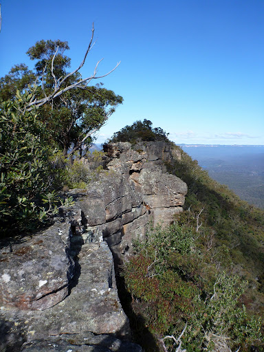
For a kilometre or more the rocky knife-edge continued, cliffs of different sizes plunging from both sides into the tree-tops below.
Our ridge didn’t do much in the way of climbing upward, rather it was happy providing an unending chain of rocky outcrops — never more than a few metres wide — broken by gaps that could be so small we could jump over, or so large as to require a serious back-track to find a way around.
As we scrambled along, taking far longer than we’d imagined from looking at the map, there was an absolute consensus that Korrowall Ridge was one of the most impressive traverses any of us had done.

Our plan had been to cross Mt Solitary, but not by the usual route. Pretty much every bushwalker has made the traditional journey — east to west — across the impressive island of rock that marks the southern boundary of the Jamison Valley, but few seem to know of the other two passes, and even fewer have visited them.
Our path, from south to north, had been inspired by a number of old trip reports. My favourite, titled “Mount Solitary (Via the Back Door)”, recorded an impressive long-weekend journey in 1935 that took a hardy group up the southern ridge of Solitary on the final day of a long-weekend jaunt.
Their trip was far more daring than ours, especially as they forced a pass up a ridge that only five years earlier had been named “Point Repulse” when another group of walkers could find no way down it. (Their trip was also interesting, and led to the naming of Singajingawell Creek — home to one of the most pleasant camp sites in the mountains.)
At some time in the early ’30’s it seems the pass was found, but the ruggedness, exposure, scrub and physically challenging nature of it has kept the hoards that otherwise crawl over Mt Solitary far away.
Our trip, planned just a few days out, was meant to have five starters, but when the train pulled in to Penrith early on the Sunday morning just one person stepped off. One more arrived on the next train, following a rather arduous battle with CityRail. The other two had decided to choose sleep and a warm bed over the wonders of nature!
We drove to Wentworth Falls where Tom’s mum helped us organise a car shuffle, leaving my car at Sublime point (where our vision of a fast moving day had us ending) before dropping us at the locked gate on Kedumba Valley Road. (Not to mention providing us with a thermos of hot tea to warm us up on what was a particularly cold winter morning.)
By the time we set off we were already about half an hour behind time, but we weren’t too worried. Talk of foosball battles passed the time as the road-bash took us to Kedumba Pass. At the top we paused to visit the Cleary Memorial Lookout — a reminder of the pioneering Burragorang families who lived in this valley long before the dam or national park. Interestingly, it was the first time I have noticed the remains of their original road, set slightly higher than the more modern water board road.
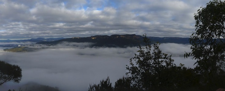
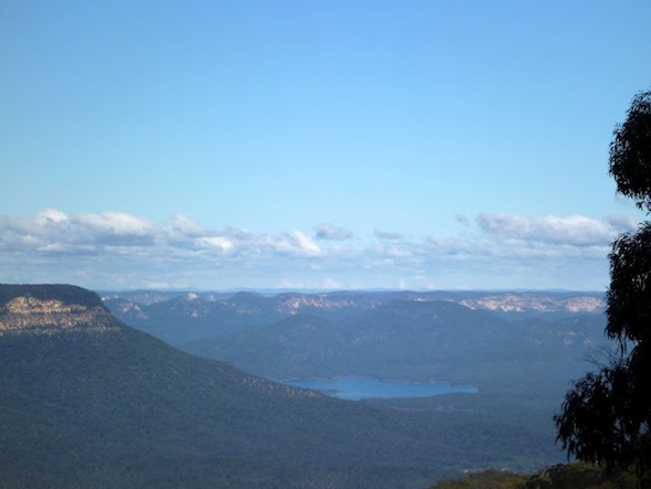
The valley was filled with a sea of mist, with the cliffs of Solitary towering above. As we walked the mist began to break up, creating a beautiful effect.
We paused to look down where the original walking pass once went, but couldn’t see an easy route from the top. One day I’ll get back to look for it from the bottom!
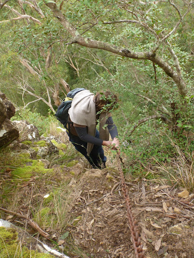
After taking the road down into the valley we turned off, again following the faint remains of the original road into the valley. At a steep point it switched back, but we pushed on, discovering the rusty old chains that made up part of what I assume is the route known as the Goat Track.
Before long we were back on the current dirt road and heading towards the remnants of the Maxwell family’s old farm at Kedumba crossing.
At the farm we stopped again, checking out the historic hut (complete with almost 60-year-old graffiti from the 1st Denistone Scouts), the ruins of a couple more building, and the well-maintained camp site. It contained the only people we saw all day.


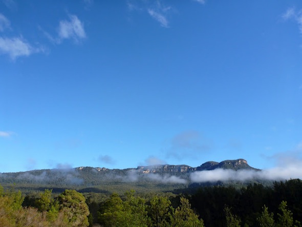
Before us we could see the impressive southern “tail” of Solitary, complete with several impressive rock pillars that we dubbed “The Twin Towers”.
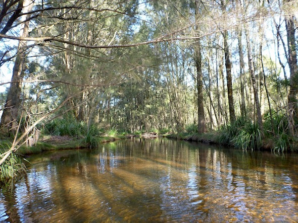
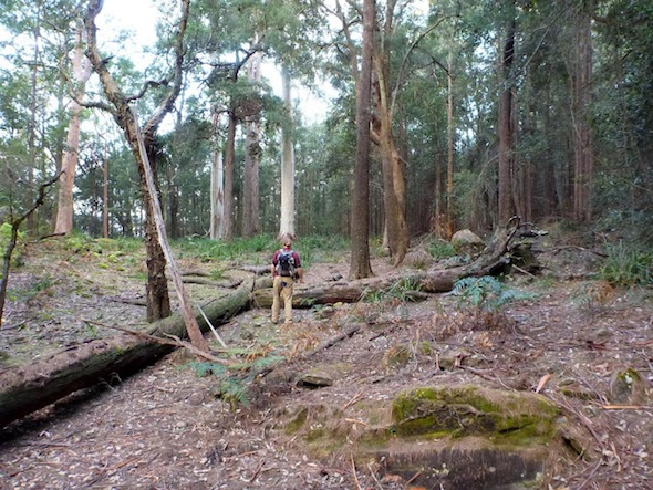
At the river the other two pfaffed about, removing their shoes so they could keep their feet dry, before we again moved off on the fire trail through attractive open forest.
We weren’t sure exactly how far we wanted to go, other than we wanted to walk the whole length of the upper ridge. Eventually, when we thought we were far enough past the last visible rocky outcrop, we set off up the hill.

As we climbed we hit a sea of cutting grass, hanging on a steep slope, leading to a small shale cliff. Thankfully we found an easy, if dodgy, break, and were soon heading up an easier incline. Towards the top there was a flattish area, where we found the remains of an old barbed wire fence (god help the poor bastards who had to build that!) which ran the final short distance to the ridge-top.
We walked between impressive trees, including the biggest paperbark I have ever seen, before the rising ridge began to be dotted with impressive chunks of fallen sandstone.
When we reached the most southerly of the towering monoliths we paused, with Bjorn free-climbing a particularly exposed route to check out the view from the top.

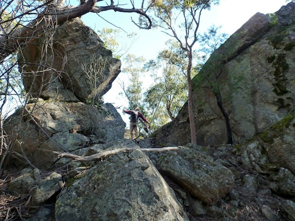
We moved on, finding easier routes to the top of the next few, and from them enjoying complete 360 degree views of the surrounding areas. Narrowneck, Cedar Creek, the Cox and behind it the High Gangerang, the Kowmung, Blue Breaks, Kedumba Walls and of course Mt Solitary itself encircled us in an amazing spectacle. It was impossible to stand on that spot without dreaming of a thousand other potential walks exploring the countless hills, mountains and valleys laid before us.
But time was ticking, and onwards we had to move. In places the ridge was easy going, but then sure enough it would throw up a challenge. There were numerous backtracks to look for a lower route, plenty of scrambling, and even some overhangs, cracks, ramps and a tunnel to explore.

There were a couple particularly challenging sections. One, which wasn’t very exposed, required some smearing of rubber on the sheer rock, which didn’t work so well for Tom with his molten rubber soles demonstrating exactly why it isn’t a good idea to dry wet shoes on the heater!
A couple others involved following relatively easy ironstone ledges set precariously over huge drops that would likely be fatal in the event of a slip.

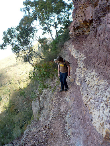
Eventually the ridge started to get some of that familiar purple gravel, which was a sign we’d hit the Mt York claystone layer that would take us to the base of Point Repulse. Sure enough, a couple minutes later and we were staring up at a most impressive sheer cliff.
Thankfully there is an extremely easy route around this (despite the name), with the only challenge being a section of very exposed, very loose shale that needs to be traversed. I nervously edged across, only to look back and see Tom and Bjorn casually leaning over to look down the drop below.
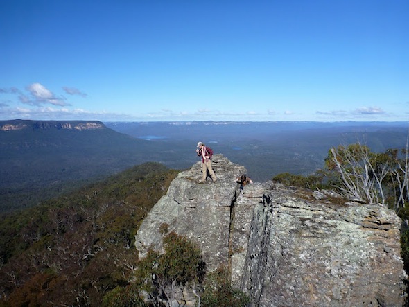
Soon enough we were up, and we set off to Point Repulse to admire the views and grab a slightly-late lunch.
Eventually we managed to convince ourselves that we had to move on — despite the pleasure of sitting on a rock in the sunshine admiring endless views — so we packed up and continued along the ridge.
From here on we endured a fair whack of scrub. Little sections of footpad came and went, never eventuating into an easy route, and the bush only got thicker as we reached the highpoint of Umbango Berrima. (As an interesting aside, I believe this is one of those invented Aboriginal place names that Myles Dunphy created. The two words basically mean “look or gaze to the south”, which is exactly what you do from here, but it is not a traditional name or even the local language from what I can tell.)
Originally we were going to head pretty well straight north to our next pass, but the valley below us seemed to cut into the rock pretty deeply, so we stuck to a thin ridge on the west. We continued along this then up the main ridge towards the actual summit of Mt Solitary.

In a saddle nearby we stumbled upon a most interesting circular rock formation, and joked that if Dave Noble was there we’d be stuck for a while as he pulled out the camera. Sure enough, he’d discovered it decades ago, and even then had paused for a happy snap!
Tom was really struggling by this point. Sleep deprivation, a hangover, and now a growing migraine were making things unpleasant for him. By the time we’d followed the track down to the camp site near Singajingawell Creek it was clear we’d need to stop for a decent break.
We refilled our water from the creek, which was flowing well, and sat on the cliff-edge to admire the afternoon sunshine. As Bjorn and I soaked in the solitude, suddenly the silence was broken by the sound of chundering behind us.

With that, it became very clear it would be suicide to try and cross the Jamison Valley — invariably in the dark — and force our way up Sublime Point via a pass unknown to any of us. Tom was still certain he could handle the old Miners Pass, but we decided we would then circle around under the mountain to the tourist track from the Col and return via Kedumba Pass.
Of course there was still the challenge of finding the pass. Bjorn scoffed at my rough idea of where it was (just look for a “distinctive tree” at the head of a small gully). What makes one of the billions of trees in the Blue Mountains distinctive? Well I wasn’t sure either, but it was all I had.
Sure enough, within a few minutes the main track took us back close to the cliffs, and there to the side was the tree at the head of a gully. Bingo! It helped that for a rarely visited pass it had clearly had a bit of recent visitation, with plenty of sliding marks down the steep slope.

We followed it under the upper cliff line, where we then headed east for a hundred metres or two. There were countless cairns, some quite large, but we still managed to loose our way at one point and look for a way down too early.
Soon enough we dropped, through an area with a few straightforward scrambles, before the pass took us west again. Finally we dropped down the last of it onto a bit of a ridge.

If anything it was so easy as to be a little disappointing. Considering how impressive these cliffs look from Katoomba I’d been expecting much more of a challenge. We’d thrown in a rope for both the passes, but in the end it hadn’t been needed for either (although it is still worth taking, and would have been useful had it been wet).
From here we sidled down and around under the cliffs of Solitary, following some of the strange flat benches in the hillside. While many were clearly natural — I assume the result of the underlying shale layers — a few sections seemed very unnatural and made me wonder just how far west the old oil shale miners had actually made it (especially as they’d used this pass up and down off the mountain). There was also a strangely flowing creek, where one doesn’t exist on the mountain above, making me wonder if it was water flowing from an old adit dug into the cliffs.
We hit several patches of ferns and lawyer vine, which at the end of a long day wasn’t wonderful, but eventually we struck the superhighway that runs down to the Kedumba River and raced down the steepest part.
It was just after 5pm when we stopped for a break. From here we knew it was all relatively easy night walking, so we were in no rush, instead working our way through our food and water to boost the energy levels for the trek ahead.
The head torches were very handy, guiding us the rest of the night through the pitch blackness, although the darkness meant we missed the turn off to the log over the river, instead getting slightly wet feet as we jumped from rock to rock through the shallow water.
As we climbed back into impressive forest we paused under the canopy, turning our lights off, to soak in the inky darkness of the moonless night.

We were all ecstatic when we finally hit the fire trail, and it gave us the second wind we needed to complete the steep push up Kedumba Pass. Some of us got more of a boost than others, with Bjorn racing along to the locked gate, then deciding he’d get cold waiting there so walking back along the road to keep us company.
Some time after 8pm we arrived, and shortly after Tom’s mum again stepped up to the plate, picking us up and taking us home for hot soup, sourdough and cold beers. Definitely better than any of the pubs in the mountains!
We’d completed a good bit more than 20kms of walking, a good chunk completely off track, as well as a very challenging pass, so as we returned to the city the legs were more than a little tired and sore, but we were all absolutely stoked by that walk and the wonders of Korrowall Ridge.

Great stuff! brought back memories from about 20 years ago when I camped on Mt Solitary, we approached from the Golden staircase end & ended up going around the back looking for a path up the Korrowall Knife edge, I can remember slip/sliding & scrambling up the loose shale!
We camped in Chanaman’s cave, was a great trip!
Excellent report lads, Myles would be proud of you.
I have been walking in the area for a long while myself and have recently been exploring new passes, slowly covering the clifflines that I think few people besides the Old Greats would have seen up close.
A while ago Dave Noble sent a friend of mine the details of the route near Point Repulse which sounded interesting, however at that stage I was busy pushing through a route past the cliffs further to the W to Berrima Inga Ridge, which I don’t think has been logged before…or maybe it is just my vanity.
Keep up the good work.
You can never be lost if you don’t care where you are.
Rodney, excellent feedback. Much appreciated. And couldn’t agree more with your sentiment that “you can never be lost if you don’t care where you are”!
Your alternate pass onto Solitary sounds amazing. Was it up the gully marked as a break in the cliffs at the eastern end of what Dunphy called Berrima Inga Bay? Or is there another break in those imposing southern cliffs we need to examine?
WIth the NPA in the 1980’s we went off Narrow-Neck, to Ruined Castle, down Cedar Creek to head round the back of Solitary, then up the ridge at the far end: it was an amazing scramble and genuinely scary as I remember it. Is that Korrowal ridge? The “shale ledge” looks familiar.. I remember that when we got onto Solitary we basically set a compass bearing and bashed the hell across the top and it was thick casuarina scrub i think. Amazing trip – wish I could remember the leader’s name, he was a classic: a real boffin, but man he could walk. He also took us for a 5 day trip along the length of the Grose, which was.. well, gross.. i would never do that again..
Julian, definitely sounds like the same ridge. “Genuinely scary” is a pretty accurate description of a couple points on the route. The addition of Cedar Creek would have been amazing. I love that creek. Although I assume you did it over two days, as it would be a very long day if you wanted to squeeze all that in! And yes, the scrub is still just as thick. It would be great to know who the leader was, and if they’re still bushwalking.
I haven’t walked w the NPA since then really but Mark Goodson or George Daniels would know (is he still around?). I remember that he was an odd ball: portly, a bit like biggles, his Lowe pack always on an odd angle, known to try things others wouldn’t. I also did Sally Camp creek in Kanangra w him, which was supposed to be a canyon but was more of a waterfall trip. There were snakes everywhere on that trip. I’ve probably got the old programs somewhere that listed the trips: they were great to get in the mail.. so many possibilities.
I hear that Rodney has apparently done not one, but two passes (excluding the buttress) off the southern side of Solitary. Never gave Solitary the attention I gave Narrow Neck, but the fact that I hadn’t even heard rumours of these suggests his may have been ‘firsts’. An amazing effort.
Definitely an amazing effort. It is amazing how many people follow the track across Solitary, but how few look further afield. I can think of one spot that looked like it may go, but the cliffs are pretty solid. I wouldn’t have thought there were two!
Seems amazing to me as well that there is no mention of these other passes, or else people have just been keeping them to themselves.
For the record they aren’t really in ‘Berrima Inga Bay’.
One that I call ‘Bitter Leaf Gully’ is amongst the cliffs to the NW of the Landslide.
The other, ‘Toorok Gully’ is the big split on the Eastern side of the Bay, can’t miss it.
Both are pretty easy, relatively.
Still looking for another pass up Narrowneck to link them up, other than Walls Pass.
Rodney, thanks for that. Some inspiration for a pass finding trip now that we’re into nice walking weather.
As for another pass up the eastern side of Narrowneck, that is the holy grail isn’t it. I’m still amazed that there is no break in that incredible length of cliff!
Hi guys, we went out there last weekend for a bit of a look (and to see how far we can get along the ridge from the top of Solitary without ropes). Unfortunately, some cretins thought it would be cool to have a roaring camp fire in that amazing ringed rock formation. If anyone who is responsible is reading this, PLEASE DO NOT DO THIS AGAIN! You have already done a lot of damage to the rock.
Linda, that’s horrible news. What kind of moron puts a fire in the middle of a sensitive rock formation (or on any rock for that matter!) Hopefully someone can find out who they are!